Shoreline Classification
The Lake Water Quality Program uses a shoreline classification system that ranks shorelines based on their relative naturalness or absence of human disturbance.
Shorelines with mostly natural features, such as aquatic and vegetation, receive higher scores. Shorelines with more human disturbance receive lower scores. The shorelines of many of the more developed lakes in the City have been classified by City staff using this system.
Shoreline properties are grouped into four categories: green (most natural), yellow, orange or red (most disturbed).
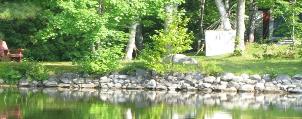
Green Shoreline
Green is the ideal type of shoreline. A buffer zone assists in filtering fertilizers, pesticides and waste that wash off lawns and driveways and into the lakes. There are:
- No hard structures.
- Many different levels of native and aquatic vegetation with a good dense buffer zone.
- Vegetation along the shoreline to stabilize the soil which will prevent erosion.
Yellow Shoreline
A yellow shoreline contains no hard structures, but grass goes right to the shoreline with no attempts at a natural buffer zone. This situation increases the likelihood of run-off from your lawn and yard into the water as well as erosion of the property due to wave and ice action.
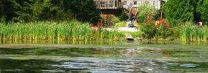
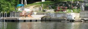
Orange Shoreline
An orange shoreline is not ideal as it contains hard structures, though there have been attempts to soften the shoreline with a buffer zone and vegetation.
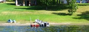
Red Shoreline
This is the least ideal shoreline. It contains hard structures and there is no buffer zone or vegetation in or around the shoreline. Property is nearly completely developed.
How is your Lake Classified?
The lakes below have had their shorelines classified by the colouring system. See how your lake is classified.
- Bethel Lake Map (PDF, 404.18 KB)
- Makada (Black) Lake Map (PDF, 480.76 KB)
- Crooked Lake Map (PDF, 514.51 KB)
- Ella Lake (Capreol) Map (PDF, 661.55 KB)
- Fairbank Lake Map (PDF, 797 KB)
- Frenchman Lake Map (PDF, 509.79 KB)
- Hanmer Lake Map (PDF, 480.32 KB)
- Hannah Lake Map (PDF, 430 KB)
- Joe Lake Map (PDF, 589.55 KB)
- Kukagami Lake Map (PDF, 452.35 KB)
- Kusk (Rat) Lake Map (PDF, 479.5 KB)
- Little Panache Lake Map (PDF, 568 KB)
- Long Lake Map (PDF, 702.78 KB)
- McCharles Lake Map (PDF, 814.78 KB)
- McFarlane Lake Map (PDF, 593.51 KB)
- Minnow Lake Map (PDF, 389.57 KB)
- Mud Lake Map (PDF, 660.5 KB)
- Lake Nepahwin Map (PDF, 1.45 MB)
- Onwatin Lake Map (PDF, 579.86 KB)
- Lake Panache Map (PDF, 640.75 KB)
- Ramsey Lake Map (PDF, 783.07 KB)
- Richard Lake Map (PDF, 541.19 KB)
- Silver Lake Map (PDF, 415.48 KB)
- Simon Lake Map (PDF, 576 KB)
- St. Charles Lake Map (PDF, 1.16 MB)
- Whitewater Lake Map (PDF, 697 KB)
- Windy Lake Map (PDF, 489.68 KB)